Free to read


The borders laid down in the Treaty of Trianon, or drawn in accordance with its provisions, follow a highly irregular course. Whether viewed on the ground or on a detailed map, their complexity is immediately apparent. This is all the more striking given that these lines had never previously formed international borders and, for the most part —with the exception of part of the Croatian section— had not even served as county boundaries. Nor do we find the long straight lines characteristic of similar artificial borders in Africa or the Americas. Straight stretches of more than half a kilometer occur only where the Trianon border follows a specific physical feature, such as the Hanság Main Canal. How, then, did such a irregular boundary—seemingly old yet entirely new—emerge between its conception in 1919 and its final demarcation in 1922–1924?
The Trianon borders were formed in two distinct stages, clearly separated in both time and consequence. The first was the boundary described in the treaty and indicated on the map in the appendix. This line, however, was more like a rough outline than a precisely defined border. The map was drawn at a scale of 1:1,000,000—providing only about half the details of a typical road atlas—and therefore determined only on which side of the border individual villages would lie. The treaty articles defining the new international borders were likewise highly schematic compared with the boundaries that eventually emerged. What the treaty did settle were the major territorial questions. It determined that the northern bank of the Danube and the Csallóköz, Kassa, Carpathian Ruthenia, the Partium and the eastern fringes of the Great Hungarian Plain, the southern territories, the Muraköz, and the Mura region would have to be ceded, while Hungary would retain the region east of the Tisza, Baja, the northern Cserhát, and the western Hungarian corridor. In this respect, the treaty was of fundamental importance. The detailed demarcation of the new borders, however, did not begin until mid-1921, following a hiatus of approximately one year.
During this period, the borders laid down in the peace treaty did not undergo any further substantial changes. It was at this stage, however, that the intricate, winding boundaries still visible today took their final form and were physically marked on the ground with boundary stones. The Treaty of Trianon did not specify the precise course of these boundaries—nor, given the constraints of length, could it have done so—but it did provide clear instructions for how they were to be demarcated. To answer the question posed above, I will first briefly examine the broad outline of the borders set out in the Treaty of Trianon and then consider some important but little-known details of how this outline was drawn up. Finally, drawing on selected examples, I will examine in detail how the boundaries were demarcated in practice and how the process differed from one neighboring state to another.
One misconception, however, needs to be dispelled. The Treaty of Trianon describes only one waterway as navigable: the Danube as a “main navigation channel” (le cours principal de navigation du Danube in the original French), from the mouth of the Ipoly almost as far as Pozsony (Bratislava). No other river is identified as navigable—not even the Tisza or the Drava, both of which were in fact navigable. Nor does the treaty say anything about the navigability of the Ipoly or the Ronyva; it merely refers to the “course of the Ipoly downstream” (le cours de l'Eipel). There was, moreover, no rule prohibiting a non-navigable river from serving as a boundary. Indeed, even the Csaronda in the Tisza region—a watercourse smaller than either the Ipoly or the Ronyva, and scarcely deserving of the term—forms the border for several kilometers.
The Role of Railways
It is perhaps an all-too-familiar commonplace that transferring the existing railway network and major railway lines to the territories newly assigned to Hungary's neighboring states—played a crucial role in shaping the Trianon borders. Broadly speaking, this is true. The allocation of the Kassa–Csap–Huszt (Košice–Csap–Khust) railway line to Czechoslovakia, the line running along the eastern edge of the Great Hungarian Plain to Romania, and the Szabadka-Zombor (Subotica–Sombor) line to the emerging Yugoslav (South Slav) state are obvious examples; indeed, control of these routes featured explicitly in the territorial claims of the states concerned. Yet it is worth reading the full text of the Treaty of Trianon: neither these lines nor the railway through the Sajó Valley are specifically mentioned in it.
Many railway facilities and lines are, however, mentioned by name and, interestingly, at this more local level the provisions tend to favor Hungary. The importance of railways in determining the border is further underscored by the map appended to the treaty, which is, for all practical purposes, a railway map. While rivers, settlements, and topographical features are shown largely for reference, the precise routes of the railway lines are carefully plotted. Most of the references to railway facilities and lines either had direct implications for the demarcation of the border or remained in the treaty as vestiges of unsuccessful territorial claims. These cases are examined below:
1. Keeping the Oroszvár–Csorna railway (today the Rajka–Hegyeshalom–Csorna line) within Hungary also ensured that the entire eastern part of the Moson Plain, including the towns of Moson and Magyaróvár, remained Hungarian. Austria had laid claim to this area as part of its territorial demands in western Hungary, which extended as far as the Moson branch of the Danube.
2. Góla (Gola) railway station lay within historic Croatia. When the former internal boundary between Hungary and Croatia became an international border, the resulting Croatian salient would have cut the Gyékényes–Barcs railway line in Hungary. The treaty therefore awarded the station and the entire section of railway concerned to Hungary. Góla was the only geographical point incorporated into Hungary under the Treaty of Trianon that had not previously formed part of Hungary proper.
3. By explicitly assigning Nagylak railway station to Hungary, the treaty effectively ensured that not only the station itself but also the Makó–Mezőhegyes railway line remained within the country.
4. Many publications claim that the Romanian border was drawn along the Szatmárnémeti–Nagyvárad–Arad (Satu Mare–Oradea–Arad) railway, an assumption that seems perfectly logical when looking at a modern map. Yet the section between Nagyszalonta and Kisjenő (Salonta–Chișineu-Criș) had not even been built when the peace treaty was drafted. This helps explain why Békéscsaba occasionally featured in Romanian territorial claims: at the time, rail traffic on this route could only be maintained via Szalonta, Békéscsaba, and Arad. The territory was ultimately not awarded to Romania. Instead, Romania was granted the right to use the existing line until a railway could be built within its own borders, for a maximum of ten years.
5. Czech troops had already attempted to seize the Csata–Losonc railway during their initial advance of 1918–1919, before the Peace Conference had even decided on Hungary’s future borders. They met with partial success, occupying the section between Losonc and Kalonda. They also captured Balassagyarmat for several days, thereby securing most of the route, but on January 29, 1919 the local population, supported by two companies of Hungarian soldiers, drove them from the town. Whether Czechoslovakia would have been awarded Balassagyarmat and the railway had they still been under Czech control when the borders were finalized is difficult to say. In any case, subsequent Czech requests for the section between Ipolyság and Kalonda were rejected by the Peace Conference, and Czechoslovakia was ultimately granted the right to use the line for fifteen years. The Czechs also sought the transfer of the Ipoly Valley railway. It is now impossible to determine whether this claim was rejected partly because Czech troops—following their expulsion from Balassagyarmat and the northern campaign of the Hungarian Soviet Republic—were no longer in control of the territory concerned.
6. A Czech memorandum submitted to the Peace Conference also proposed placing the Pozsony–Murakeresztúr railway under Czech, or joint Czech and Yugoslav, control as part of the planned Slav corridor through western Hungary. The original scheme aimed to take control of the Pozsony (Bratislava)–Nezsider (Neusidl am See)–Sopron–Szombathely–Murakeresztúr route, part of which now runs through Austria. Once the Peace Conference had rejected the corridor scheme and awarded part of the territory to Austria, the Czech objective shifted to ensuring that at least one route remained in Hungarian hands. This was the Oroszvár–Csorna line.
The Demarcation of the Borders
The Hungarian delegation signed the peace treaty on June 4, 1920, and the Hungarian National Assembly approved it on November 15 of the same year. Under the terms of the treaty, it would only enter into force when it had been ratified by Hungary and by at least three of the Principal Allied and Associated Powers—France, the British Empire, Italy, Japan, and the United States. The ratification process took another year. After Britain and Italy, Japan became the third of the Allied powers to ratify the treaty in June 1921, while France was the last to do so, in July. Only then could the actual demarcation of the borders begin. The United States never did ratify the Treaty of Trianon, either at the time or subsequently, just as it never ratified any of the other Paris peace treaties. Instead, the U.S. concluded separate bilateral peace treaties with the states concerned.
Until the summer of 1921, much of the southern part of what would become post-Trianon Hungary remained under Yugoslav occupation. Yugoslav forces held the territory south of the armistice line established in November 1918—the Barcs–Mecsek–Bátaszék–Baja demarcation line—and controlled the entire Barcs–Pécs–Baja–Szabadka (Subotica) railway. They also occupied the Muraköz and Mura regions, as well as several border areas in present-day Vas and Zala counties. On the Romanian and Czechoslovak fronts, by contrast, the occupying armies had withdrawn to the demarcation lines broadly corresponding to the boundaries outlined in the peace treaty. In western Hungary, meanwhile, the territories awarded to Austria remained under Hungarian administration.
Articles 43, 46, 50, and 71 of the peace treaty stipulated that a seven-member commission was to be established for each section of the border shared with the future neighboring states—four commissions in total—comprising representatives of the countries concerned and of the five Principal Allied and Associated Powers. The role of the Council of the League of Nations in settling disputes can also be inferred from the opening articles of the treaty governing the operation of the League (Article 4). Article 363 states: “Except where otherwise provided in the present Treaty, in all cases where the Treaty provides for the settlement of a question affecting particularly certain States by means of a special Convention to be concluded between the States concerned, it is understood by the High Contracting Parties that difficulties arising in this connection shall, until Hungary is admitted to membership of the League of Nations, be settled by the Principal Allied and Associated Powers.”
In practice, this authority was exercised by the Conference of Ambassadors. Chaired by the French foreign minister, it included the British, Italian, and Japanese ambassadors to France, while the American ambassador attended its meetings only as an observer. On July 20, 1920, the Conference adopted the rules governing the work of the boundary commissions, and added further instructions on June 3, 1921. These instructions finally put an end to Hungarian hopes that the boundary line, however schematically defined in the treaty, might still be substantially revised.
In the absence of American delegates, each commission was made up of six members. The French delegates chaired the Austro-Hungarian and Romanian-Hungarian boundary commissions, while their British counterparts headed the commissions responsible for demarcating the Yugoslav-Hungarian and Czechoslovak-Hungarian borders. Decisions were taken by majority vote. Given the even number of members, however, the chairman’s casting vote in the event of a tie assumed particular importance and would later prove decisive in determining the fate of at least two villages. Whenever the two states concerned agreed on an issue relating to their shared section of the border, the Entente representatives also accepted the solution they had reached.
The task of the boundary commissions was to turn the boundary line broadly outlined in the Treaty of Trianon into a definitive border. They were given considerable freedom in doing so, provided that they adhered strictly to the terms of the treaty and that all the parties concerned were in agreement. The parties concerned could appeal a commission’s decision to either the Council of the League of Nations or the Conference of Ambassadors, undertaking in advance to abide by the decision reached. The same bodies had to be consulted whenever a boundary commission proposed a departure from a point specifically identified in the treaty that would also affect an inhabited area. In practice, however, the party concerned would inevitably object to, and therefore appeal, such a proposal in any case.
The Boundary Commissions
The boundary commissions began their work in August 1921. The four differed considerably in their approach, working methods, and, to some extent, even in their degree of “leniency”; these differences were reflected both in their decisions and in the final course of the borders.
The Austrian border was the clear exception. The key legal distinction was the absence of any direct treaty between Hungary and Austria governing the border or, indeed, any other aspect of the peace settlement, including the work of the boundary commissions. Austria had concluded its peace treaty with the Entente powers at Saint-Germain in September 1919, and Hungary at Trianon in June 1920. Czechoslovakia, Romania, and Yugoslavia were signatories to both treaties, and the Treaty of Trianon thus established a direct treaty relationship between Hungary and each of these states. No comparable relationship existed between Hungary and Austria. The Austrian border was also exceptional because the Entente representatives were not “officially predisposed” towards either side. France, Britain, Italy, and Japan had signed the Treaty of Trianon on the victorious side alongside Romania, Czechoslovakia, and Yugoslavia; Austria, by contrast, had not. The boundary commission therefore had greater scope to adjust the Austrian border, and it made effective use of this latitude.
Smaller, though still significant, differences also emerged among the commissions responsible for the other borders. The “strictest” was the commission charged with determining the Hungarian–Romanian border, as its rules of procedure made clear from the outset. Each side was required to submit all its proposals in a single package. If these were rejected, the commission could proceed directly to determine the final border, leaving no opportunity to return with more limited claims. The proposals also had to be presented on cadastral maps within a very short deadline. Yet the relevant maps were held in archives that had ended up beyond Hungary’s new borders—even in the case of areas awarded to Hungary—and were not recovered until later. Consequently, the Hungarian side was unable even to put forward proposals for substantive changes to the Hungarian–Romanian border.
The Czechoslovak and Yugoslav boundary commissions were somewhat more receptive to the Hungarian proposals. There was, however, no question of concessions on the points and lines regarded as fundamental to the peace settlement. In the case of Czechoslovakia, the “lines that could not be crossed” were the borders along the Danube and the Ipoly, together with the railway running via Kassa and Csap towards Subcarpathian Ruthenia. On the Yugoslav border, any proposal to leave the region of the Mura and the Baranya Triangle within Hungary proved unacceptable to the commission. Even so, both commissions approved minor adjustments in Hungary’s favor, including changes affecting inhabited areas. One of these proposals was subsequently upheld, at least partly, on appeal.
Perhaps surprisingly, not only Hungary but also the opposing state could propose changes to the Trianon boundary. Where such proposals affected inhabited areas, the Czechoslovak and Yugoslav boundary commissions consistently rejected them. Once again, however, Austria proved the exception: the commission accepted such a proposal on the Austrian border, and the boundary still follows the resulting line today. We now turn to four cases of proposed boundary changes that illustrate the scope available to the Hungarian side before the commissions and the extent to which its efforts did—or did not—succeed.
Sopron
The most important chapter in the history of the post-Trianon boundary adjustments concerns Sopron and the surrounding area. After the Treaty of Trianon came into force, the Hungarian state planned to withdraw its civil administration and armed security forces from the territory of the future Burgenland in two stages. Following the evacuation of the first zone, armed clashes broke out in late August and early September 1921 between Austrian gendarmes moving into the area and Hungarian irregulars.
The Austrians chose not to press the matter. The Hungarian government washed its hands of the affair, maintaining that it was no longer responsible for events in the territory, while the Austrians, after several unsuccessful exchanges of gunfire, decided to seek a solution from the Entente. This was not entirely without justification: Austria’s treaty was signed with the Entente powers, and Vienna expected them to hand over the territory “on a silver platter.” By the second half of 1921, however, the Entente no longer had any forces in the region that it could deploy to deal with conflicts of this kind.
In this case, Austria experienced at first hand what it was like when the Entente simply issued orders but lacked the military power to enforce them—a situation on which the Károlyi government could also have had much to say in connection with the increasingly disadvantageous demarcation lines in Transylvania and Upper Hungary and their repeated violation. In this particular case, the British envoy merely advised the Austrians not to deploy the army, as doing so would constitute a breach of the peace treaty—although, had they done so, Sopron might well belong to Austria today. The Austrians even attempted to negotiate with the Czechoslovaks: at Hainburg in late September, Foreign Minister Beneš advised Austrian Chancellor Schober to offer Sopron in return for Hungary's transferring the remaining territories awarded to Austria.
This solution took shape in the Austro-Hungarian agreement signed in Venice, Italy, on October 13, 1921, which finally established a direct treaty-based relationship between the two countries on the question of the border. Under its terms, Sopron remained a nominally Entente-controlled, demilitarized zone pending the plebiscite of December 14-16, in which roughly two-thirds of the votes were cast in favor of Hungary. The boundary commission played no part in the process: the matter was settled at a higher level, and the result of the plebiscite was ultimately endorsed by the League of Nations. It is perhaps no exaggeration to suggest that, for the Entente powers, Charles IV's second attempt to regain the Hungarian throne and his subsequent deposition were the more pressing developments of the period.
The Pinka Valley
At several other points, the Boundary Commission also proposed modifications to the Trianon line of the Austro-Hungarian border. The Hungarian delegate submitted a proposal for changes affecting no fewer than 96 (!) settlements. Although it received the support of a majority of the Commission, the proposal eventually reached the Council of the League of Nations, where it was rejected. Hungary subsequently put forward a more modest proposal, while Austria likewise suggested a number of minor adjustments.
The Commission visited the settlements affected by the proposals, heard the preferences of the local population, and based its decisions largely on these views. It recommended that Kisnarda and Nagynarda, Alsócsatár and Felsőcsatár, Horvátlövő and Pornóapáti in the Pinka Valley, as well as Rendek and Rőtfalva north of Kőszeg, be assigned to Hungary. The villages of Csém and Csajta remained in Austria, since their transfer to Hungary would have severed the Felsőőr–Rohonc railway line. Hungary’s claims to Pomogy, Ólmod, Szentpéterfa, Léka, and Hámortó were rejected. Austria was awarded the village of Lovászad (Luising), whose inhabitants had expressed their preference for Austria, but its claims to Zsira and Nemesmedves were rejected.
The Council of the League of Nations approved the Commission’s proposal in September 1922. This was therefore a decision formally adopted by the Boundary Commission and subsequently upheld by the higher authority responsible for reviewing it. Hungary and Austria then also reached a bilateral agreement to exchange two villages on each side, together with several outlying areas.
Somoskőújfalu
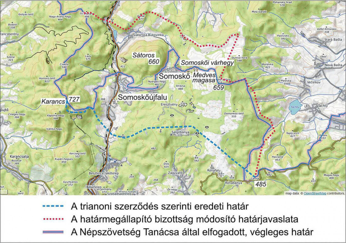
In legal terms, the case of Somoskőújfalu and Somoskő followed a very similar course. The Czechoslovak–Hungarian Boundary Commission proved considerably more rigid: this was the only proposed modification that ultimately succeeded. To the north and northeast of Salgótarján, the Trianon boundary ran from Zagyvaróna, passing to the north of the Salgó mining settlement and the mountain peak, and then continuing towards the Karancs, leaving the villages of Somoskő and Somoskőújfalu on the Czechoslovak side. Citing economic interests—above all the crucial importance of the basalt quarries of the Medves region for paving the streets of Budapest—the Hungarian side initially requested the return of Somoskő. Although this would have resulted in a rather convoluted boundary line, it could still be accommodated within a literal interpretation of the Treaty of Trianon, and the Commission accepted the proposal.
At this point, the Hungarian delegate “raised the stakes” and also requested the return of Somoskőújfalu, citing its Hungarian population and the importance of the local stone quarries. This, however, conflicted with the wording of the treaty on two counts: the village, listed as “Somosújfalu,” was explicitly identified as being assigned to Czechoslovakia, while the proposed modification would also have removed the summit of the Karancs—likewise specifically mentioned as an elevation point—from the boundary line. The higher stakes nearly proved fatal to the proposal: the Commission was split three votes to three, and the deadlock was ultimately broken by the British chairman’s casting vote in favor of Hungary.
The proposal was referred to the Council of the League of Nations, which, in April 1923, after hearing the Council’s military commission, awarded the two villages to Hungary while leaving the heights in their outlying territories—including the iconic fortress of Somoskő—to Czechoslovakia. In this case, therefore, the higher authority accepted the Boundary Commission’s proposal only in part: the frontier was modified in Hungary’s favor, but not to the extent originally requested. Hungary could nevertheless also count as a success the Commission’s rejection of Czechoslovakia’s proposal to transfer the village of Susa (now part of Ózd) to Czechoslovakia in contravention of the Treaty of Trianon.
The Lendva Region
For a long time, the Yugoslav–Hungarian Boundary Commission’s dispute over the Mura region appeared to follow the Somoskő precedent, but it ultimately ended without success. Hungary’s original request to retain the whole of the territory was rejected. Following an on-site inspection, however, the Entente delegates unanimously supported leaving 27 mostly very small border settlements within Hungary. At the same time, they ordered the Yugoslav forces to withdraw from Szomoróc, which had been awarded to Hungary under the Treaty of Trianon, as well as from Szentistvánlak, which was not mentioned in the treaty. The Yugoslav side appealed against the decision to modify the boundary, and its appeal was upheld by the Conference of Ambassadors in November 1922.
Why Are These Brand-New Borders So Irregular?
The process described above effectively determined which settlements would remain in Hungary and which would have to be ceded to the neighboring states. We have now reached the point where we can answer our original question: why are these brand-new borders so irregular?
The answer is that, although they are brand-new international borders, they are—like borders of any kind—far from entirely new. At the very outset of their work, the Boundary Commissions decided that, wherever possible, the new state frontiers should follow existing municipal boundaries. The administrative, or cadastral, territories of the settlements had themselves taken shape much earlier, as the product of a long and organic process of historical development. These administrative boundaries were shown on large-scale cadastral maps, while the boundary lines themselves were also marked on the ground with stakes and stones. The territories of individual settlements fit together rather like pieces of a puzzle to form the maps of counties and countries. If cadastral boundaries are preserved, a change to an international frontier can therefore produce a different overall shape from the very same puzzle pieces. As long as the edges of those pieces are irregular, the national border assembled from them will inevitably be irregular as well.
The first attempt at cadastral mapping in Hungary was undertaken by Emperor Joseph II. After his death, however, the nobility, fearing that the surveys might pave the way for a land tax and thus undermine the tax exemption guaranteed to them by the Golden Bull, destroyed the completed maps and records. Systematic cadastral mapping in Hungary did not begin until 1856, during the period of Austrian rule following the 1848-49 War of Independence, with the preparation of the so-called “provisional land-tax” maps. The survey that formed the basis of the modern cadastral system was launched in the late 1860s. These maps recorded municipal boundaries that had already developed over time. In reality, there was little alternative: establishing an entirely new boundary line, mapping it, and physically marking it out on the ground would have involved an enormous amount of additional work, and wherever this was unnecessary, it was simply not undertaken.
The Boundary Commissions, however, did not just take into account the cadastral boundaries but also the Trianon boundary sketch, which in some places conflicted with them. Wherever possible, they also considered local economic conditions, the wishes of certain large landowners, and tended to cut off administrative territories that projected particularly far beyond the main boundary line. In fact, decisions of this kind accounted for the greater part of the Commissions’ work, and their cumulative effect produced a net gain of several hundred square kilometers for Hungary. To illustrate the different ways in which conflicts between cadastral boundaries and the Trianon boundary sketch were resolved, I shall examine the entirely contrasting practices adopted by the Czechoslovak and Austrian Boundary Commissions.
The northeastern part of the border section between the Bódva and Sajó rivers runs through the Aggtelek Karst region. The Trianon boundary description defined the frontier by means of just six elevation points, spaced eight to ten kilometers apart—leaving the Commission to make of this what it could. At the eastern and western ends of the section, the elevation points lay on municipal boundaries, so it was logical to retain these lines when “dividing up” the villages and, with them, the surrounding territories. At the eastern end of the remaining stretch, two “mandatory” boundary points lay a few hundred meters from the cadastral village boundaries. Here, most of the village boundaries were retained, while the international frontier makes a series of sharp, otherwise rather inexplicable detours to reach the elevation points before returning to the cadastral lines.
As a result, every elevation point specified by the treaty as lying on the Czechoslovak–Hungarian frontier was incorporated into the boundary as actually demarcated. The sole exception was the pass on the road between Hollóháza and Eszkáros, where, by retaining the cadastral boundaries, Hungary lost slightly less territory than the treaty would have required.
The Austro-Hungarian Boundary Commission adopted an entirely different approach. Across the plains of Moson and the Hanság, the frontier still passes through the designated elevation points, even though these mark no discernible features in the otherwise flat landscape. In the hills of the Alpine foothills, however, with a single exception, it does not. The Kamenje summit east of the village of Füles (Nikitsch) does not lie on the frontier but is located in Austria; likewise, nor do any of the peaks along the watershed north of the Rába, while Janke Hill, southwest of Szentgotthárd, lie on the frontier—the latter peaks all remained in Hungary. The reason for this was the consistent application of a principle accepted by both parties: cadastral boundaries were not to be taken into account when demarcating the international frontier unless there were compelling reasons to do so.
There was, however, one exception, when the Hungarian delegation, lodged a complaint—and succeeded. The case concerned Írottkő, the 883-metre summit of the Kőszeg Mountains, the highest point on the Austro-Hungarian frontier and the second-highest point anywhere on Hungary’s international border. Today, the state frontier runs directly across its summit. This seems entirely appropriate, since the point is specifically mentioned as a boundary point in both the Treaty of Trianon and the Treaty of Saint-Germain.The problem is that the cadastral boundaries of the four neighbouring settlements—Rohonc, Léka, Hámortó, and Bozsok—do not meet at the summit in a four-way junction. Only the territories of Hámortó and Rohonc meet there, and neither settlement remained in Hungary. The lookout tower, and thus the summit itself, lay approximately twenty meters west of Bozsok’s original boundary. Hungary therefore requested, and was granted, a boundary adjustment of some 160 square meters, which made it possible to reach the lookout tower without a passport.
Divided Settlements
In discussions of Trianon, one often hears claims that “the border was drawn down the village’s main street” or that “settlements were cut in two.” In light of the process described above, such cases could only have occurred as very rare exceptions; and when the specific examples are examined, virtually no such cases can in fact be found. The division of cadastral municipal territories occurred in the following circumstances:
1. When the Danube—as a boundary line explicitly laid down in the treaty—cut across a municipal territory. The most obvious example is Komárom, which was indeed divided in this way, but several villages in the Csallóköz region also possessed outlying territories on the Szigetköz side of the Danube. Similarly, smaller watercourses sometimes resulted in substantial outlying areas being cut off—for example, along the border between the Tiszahát region and Subcarpathia, where Csaroda formed part of the boundary.
2. When a railway line or railway facility required the frontier to depart from a municipal boundary. The most striking example is Sátoraljaújhely, whose former main railway station stood on the ceded Kassa–Csap railway line; as a result, the new frontier also affected the town’s infrastructure, including its waterworks. West of the old village of Nagylak—which had to be transferred—the railway line remained in Hungary, and it was there that the present-day Hungarian village of Nagylak was built, effectively as a “greenfield development.” Another example is the designation of Kötegyán station as a boundary point. As a result of the associated negotiations, a substantial part of Nagyszalonta’s municipal territory remained in Hungary, where, in effect, another Nagyszalonta was built. In 1940, following the Second Vienna Award, the two settlements were not merged; instead, the newly built one was renamed Újszalonta, the name it still bears today.
3. When, in response to local economic interests—for example, at the request of an influential landowner—a particular area was transferred to the other side of the frontier. This is how the Esterházy forest estate, on the northern side of the ridge of the Kőszeg Mountains, remained in Hungary despite forming part of the cadastral territory of Rőtfalva, which was ultimately ceded. Albertkázmérpuszta similarly remained in Hungary although it had belonged to the cadastral territory of Féltorony, which also had to be transferred to Austria.
4. When preserving a settlement’s cadastral boundary would have produced a frontier with an excessively pronounced salient or indentation, as in the cases of Geszt and Harsány on the Romanian border.
5. The case of Szabadka, where the unambiguous Trianon boundary description awarded Hungary the northern part of the outlying territory of a town with an enormous cadastral area of around 1,000 square kilometers. The Yugoslav delegation claimed the entire area before the Boundary Commission, prompting Hungary to move quickly to establish the municipalities of Tompa and Csikéria—and, a few years later, Kelebia as well—in order to avoid the loss of more than 100 square kilometers of territory that might otherwise have resulted from a cadastral-based adjustment.
Apart from the cases discussed above, there was one further exception: the already mentioned case of Somoskőújfalu, where the final frontier bore no relation either to the Trianon boundary description or to the line proposed by the Boundary Commission. It was drawn on a map by the military commission of the Council of the League of Nations from a distance of 1,000 kilometers, with no knowledge of local conditions, and cut across the built-up areas of both Somoskőújfalu and Somoskő. In contrast, one may cite the village of Tajti, not far east of Somoskő. Under the treaty’s boundary description, the village should have been divided, since the watershed between the Rima and Tarna rivers passes through its built-up area. As Hungary would have received the smaller part of the village if it had been divided, the Hungarian side gave way, and here, too, there was ultimately no “border down the main street.”
While the overwhelming majority of the Trianon frontiers ran between settlements—that is, along lines already familiar as boundaries of a kind—they generally caused no immediate practical problems for the settlements themselves. The severing of established economic and social ties, of course, led to the impoverishment of entire regions. In the cases of Somoskőújfalu and Sátoraljaújhely, for example, some of the resulting problems have persisted to the present day. After the First Vienna Award of 1938, these two settlements, whose built-up areas extended all the way to the frontier, were able to “breathe a sigh of relief” and began to expand beyond what was then a temporarily non-existent border, laying water and sewer pipes there. In 1945, however, the old frontier was restored, first as an armistice line and then definitively following the Paris Peace Treaty of February 1947.
The confused situation was resolved by a territorial exchange agreement in 1952. The two states exchanged areas of equal size in and around these two settlements and also along the Ipoly, where regulation of the river under Hungarian administration had altered its course. This brought to an end the unusual situation in which Somoskő could be reached only by a main road running directly along the frontier. Today, only a single street in Somoskőújfalu remains a “border road”; plans for a further minor territorial exchange are under way to resolve this situation as well.
Boundary Stones
The final outcome of the decision-making process described above was a boundary line marked on the ground, represented on maps, and precisely defined in written descriptions. In most places, the boundary is marked by boundary stones, which had to be positioned so that—at least when they were originally installed—each was visible from the next. The boundary markers and stones followed a uniform structure, precisely defined in the technical sections of the instructions and supplementary instructions issued to the Boundary Commissions by the Conference of Ambassadors. The frontiers with the individual neighboring states were divided into shorter sections. The designation of these sections, however, was not prescribed by the instructions, and consequently their numbering or lettering, as well as their typical length, varied considerably from one frontier to another.
The tripoints marking the meeting of three countries—the so-called triplexes—were given distinctive and individually designed markers in the field. From a technical point of view, the Hungarian–Romanian–Czechoslovak tripoint (today the Hungarian–Romanian–Ukrainian tripoint) is particularly interesting. Since the actual point lies in water, the common boundary point is defined as the center of the triangle marked by three boundary stones. The remaining boundary stones form a predetermined and uniform system for each frontier: the type immediately below the tripoints in the hierarchy, for example, marks the boundaries between individual frontier sections.
Boundary stones may stand alone, with markings painted on their tops indicating the direction of the neighboring stones, or they may be erected in pairs, in which case the midpoint between the pair constitutes the boundary point. Along wider rivers, such as the Danube or the Dráva, boundary stones stand in pairs on opposite banks. In such cases, the boundary is not necessarily at the midpoint of the line between them; instead, the accompanying written description specifies the precise position of the boundary point along the line connecting the pair. Individual numbers and codes on the stones identify the type of marker. In addition, large-scale maps and corresponding boundary descriptions were prepared for the entire frontier, precisely defining the course of the boundary in relation to the boundary stones and other features on the ground.
Manufacturing the boundary stones from the materials and according to the specifications laid down in the technical instructions, installing and marking them, and preparing the boundary maps and written descriptions involved an enormous amount of work and occupied the geodetic resources of the countries concerned for several years. Here, the fact that the overwhelming majority of the boundary line had previously existed as municipal or settlement boundaries assumes particular importance. Although marked in a much more rudimentary fashion, these boundaries were already indicated on the ground and recorded on cadastral maps. This greatly facilitated and accelerated the process of marking the new international frontier. Wherever the frontier departed from these pre-existing settlement boundaries, however, a new local survey had to be carried out and the stones positioned accordingly.
The boundary descriptions specify not only the course of the frontier but also the coordinates of every boundary stone. Interestingly, this was the first large-scale nationwide surveying project in the history of Hungarian land surveying to be completed entirely in the metric system. The coordinates could, in any case, only be given in the coordinate systems used by the existing cadastral maps. The positions of the points in the boundary descriptions were therefore expressed numerically in meters and according to the Hungarian cartographic coordinate systems of the period (for most of the frontier, the so-called Gellérthegy stereographic system was used). These systems have long since ceased to be officially used elsewhere; only in the documentation of the international boundary have they survived as official reference systems.
(translated by Márta Pellérdi)